Exactly three hours and thirty minutes into this year’s December Chill adventure race, I had to wade through a creek, knee deep. This was a significant improvement over last year, when I went through ice on a swamp merely fifteen minutes into the race. And the weather was warmer today, too: about 30F and maybe even over that a few times. Good times!
Here’s the reason for the wading. I was on the final orienteering section of the race. There was a decent, 10-20-foot wide creek bisecting much of the area. I had already crossed it twice, using fallen logs, which are usually a splendid means but not when there’s a quarter inch of snow on ‘em. (Read: slippery as all get-out. I had to do the woefully unmanly all-fours crossing in one case, and still got some water contact.) The checkpoint I had just found had clue sheet instructions that read: “There are some rocks in the creek at this point, but you will get wet.” Fine, I figured, I’ll get wet. And I did. Not so bad. At first it feels chilly, but then it feels… well, still chilly, but not so much.
This was my third December Chill, and the most successful so far. Whether the official results bear the success out remains to be seen, but almost everything went well, and apart from a couple of mistakes that maybe cost me five minutes, nothing went wrong. In adventure races, part of the challenge is that lots of things can go wrong.
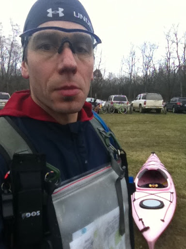 |
| A self-portrait after the race. |
This year, the race was in the Genesee county parks in rural areas near Flint. That meant getting up at 3:30 a.m., walking the dog, and then leaving the house by 5 a.m. Some logistics involving dropping off my kayak in one place and bike at another, neither of which were the race headquarters, required this.
The race began with a trail run that involved some but not much navigation and which took us to our bikes. Then we biked just three miles, just on the dirt roads, to the paddling launch at the Holloway Dam on the Flint river. The paddling section was all downriver, which I very much enjoy but also feel slightly guilty about: Shouldn’t I be working harder? It was about five miles, with one (muddy) checkpoint along the way. As I passed a canoe, one of the guys in it asked, “Is a pink kayak faster?” I felt like saying, “Apparently, jackass, since I’m going by,” but you never know if those guys might need to rescue the next minute. So I said something noncommittal.
Interestingly, although the river was pretty fast, the layer of ice that formed over the deck of my kayak (and map, and paddle shaft) probably added some weight and slowed me a bit. So I didn’t feel so fast today.
After the paddling, it was back on the bikes, which the race organizers had kindly moved to the takeout location. Another fourteen miles of country roads in Genesee county. The only interesting part, I felt, was having to throw the bike over an eight-foot fence and then climbing it myself. A longer detour involving no fences would have been available, but it didn’t seem worthwhile.
The Chill is a seven-hour sprint, which means you’ll have to compete the course in seven hours or not get ranked. Fabulously, I arrived at the race headquarters — at the Elba Equestrian Complex, alas sans equines today — with a full four hours left for the final orienteering course. Infiterra Sports’ adventure racing usually means that the first to finish isn’t the winner; the person or team to get most checkpoints fastest wins. So I was all excited about having this time to go for the twenty-two optional orienteering checkpoints.
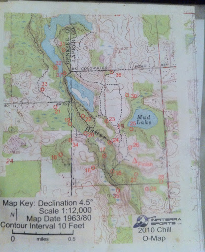 |
| As you can see, the orienteering course took some strategizing. |
Twenty-two sounds like a lot, but they were pretty closely placed: usually you wouldn’t have more than a quarter of a mile between two points. The way they were placed required some strategizing, and I think my strategy was good if not the most ideal. Still, it went well. It may have helped that I had done a race in the same location a year and a half ago: I kind of remembered some of the terrain — one horrible reentrant which Michiganders have treated as a dump for decades in particular — and I was wise to the topo map being based on a 1963 image! Swamps turn into lakes and lakes turn into swamps in fifty years, and railroads and roads disappear.
The changing limnological terrain did require one more small adventure. At exactly four and a half hours into the race, I had to wade across a lake. The map showed a swampy area between two small lakes, but as time and chance happen to us all, they had connected these two lakes. Fortunately, the water level was low, so it was merely a thigh-deep wading.
And I was almost done! I finished the race in about five and a half hours, “clearing the course,” as they say, that is, finding all the optional checkpoints. I hadn’t been cold during the race, but afterward I was, having neglected to bring a change of clothes. My fingernails returned to their natural peachy color from the purple they had sported by Flint, so a mere twenty minutes into the drive home, and a twenty-minute shower at home took all the pain from my freezing toes.
(Infiterra’s photos of the race are here.)
