Saturday, May 7, 2011
2:55 a.m. Wake up without alarm, in anticipation of alarm about to go off at 3:00 a.m. Walk the dog, feed dog and self. Caffeinate self. Get ready to head out to Pinckney State Recreation Area for Infiterra Sports’ Spring Fury 10-Hour Sprint Adventure Race. In adventure racing, anything short of 24 hours is a sprint.
7:00 a.m. Race begins with a brief half-mile out-and-back run up a hill, simply to ease the congestion at canoe and kayak put-in. The paddling will have a brief interlude of orienteering based on a satellite image instead of a topo map. Then there’ll be by biking, mainly roads, some trail. Finish with a longish orienteering course. The sun is up, promising a far better day than forecast. Amazing sandhill cranes hang out pretty near the running course. The pink kayak is the fourth boat in water. My best standing in the race for the rest of the day.
7:41 a.m. Arrive at Blind Lake, checkpoint 2, to take out and head for a brief orienteering course. Receive satellite image map, probably about 1:5,000 scale (which is very confusing, given the usual 1:24,000 or 1:15,000 scales). Although the orienteering area is pretty familiar to me, I make probably the most important mistake of the day and choose a clockwise direction in which to get the five checkpoints. Also, with this scale, it’s very easy to overshoot your targets, which I and many others promptly do. Some delay in getting the first two CPs.
Very dark area on the satellite image implies wet, marshy area. The implication is correct. Bushwhack through 300 meters of swampy thicket, hip-deep in mud, between two checkpoints. Repeat on getting back on the trail. Make a few other stupid mistakes, and this section takes 45 minutes longer than it should have. Goodbye a decent placement.
9:07 a.m. Back in the kayak and on the way to get the rest of paddling checkpoints. The only complication is a metal tunnel between two lakes at slightly different levels: paddling upstream when other boats are coming through is somewhat hairy. Capsize avoided, though.
10:27 a.m. Eight miles of kayaking finally over (see here for the route). Spent the last fifteen minutes paddling furiously, overtaking three boats. Hop on the bike, which is always frustrating right after kayaking: when your legs have been forced into immobilization for several hours, they are not happy to have to move a lot. Road biking is uneventful. In the middle of the biking section, there is about four miles of single-track riding on the famous Potawatomi Trail. It’s regarded as the most fun MTB riding in SE Michigan. I regard it as frustrating and scary, but this early in the season, it is actually fun. No falls, and at times I fly. In general, much of the biking section feels rewarding. I usually suck on the bike, but since I’m so far behind the leaders, I’m with the midpackers, whom I regularly pass.
Around 12:30 p.m. I’m on the optional biking section when total depletion sets in. Clearly I have mismanaged my eating. (Read: didn’t eat enough.) Eat a Mojo Bar and wait for the energy to kick in. It would be wrong to say second wind arrives; it’s more like a light breeze. Then, nasty leg cramps. Pop an electrolyte tablet, wait for relief, and notice that cramps are eased by hard pedaling.
1:14 p.m. Twenty-six miles of biking has taken me 2 hours and 46 minutes. Pathetic. Eat my sandwich, get the orienteering map, put on trail shoes which have almost dried in the sun after the morning’s swamp-stomping. The orienteering course has 19 checkpoints, only five of which are mandatory to stay ranked. Seriously tempted to go just for the five and go home.
Also, it’s the first really warm day of the spring. So I am a bit too warm.
These checkpoints can be obtained in any order. The first few I go for are ridiculously easy, thanks in part with my familiarity of Pinckney Rec. But at CP 36, difficulty arises. There is no convenient trail or other landmark from 37 to 36, so I actually take a bearing with my compass, measure the distance, and head into the right direction with a pace count. The cue for CP 36 is “Rock pile.” I feel super-proud of my nav: I hit the rock pile exactly when my pace count says I should. My best navigation ever!
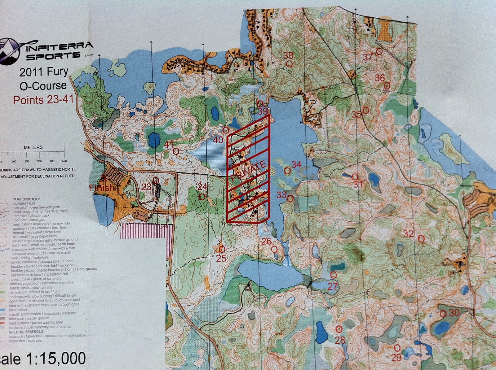
 The only problem is, CP 36 is nowhere to be seen. Sometimes locals remove CPs for fun, but this is in a thicket that locals are unlikely to come when it’s not hunting season. Maybe I am at the wrong rock pile? But another racer, a very talented navigator, arrives at the same spot. We hit the power line just south of where 36 should be, turn back, and start scouting the terrain. A team arrives from east, saying they’ve found 36 simply because they had been off course. Instead of a rock pile, 36 is in a marsh, placed low to the ground, right underneath a power line, 100 meters to the east of where it should have been. (See the detail of the map on the left.) Grr. Fifteen minutes wasted! But what’s nice is that even though we are in a competition, racers are willing to help one another find the CP.
3:41 p.m. I run out of water. OK, I should have filled my CamelBak at the transition area because clearly three liters of liquid is not enough, but I was hurrying. Getting CPs 34 and 33 is kind of fun as it involves more wet marshy stuff — marshes may be slightly dangerous, and certainly very gross, but they do cool you — but then it’s time to evaluate how much I want to get a few more CPs. There will be a bunch that are easy, but my ankle tendinitis is finally rearing its head, I know I’m out of the running for the top dozen, and the thought of home is appealing. So let’s head to the finish, get the few CPs along the way, and be done! Some more bushwhacking and swamp stomping ensue.
4:11 p.m. Finish the race, with forty-nine minutes to spare from the cutoff, with four checkpoints missed. Slightly pathetic, but I have enjoyed the day, all the same. And as I walk from the finish to the car to pack up my gear, two sandhill cranes fly by, very low, looking like the ancient birds they are and making their haunting sounds. A good day!
